Thursday, 27 December 2018

Sandhan Valley -The Grand Canyon of the East - Ek Bhatkanti

A Scene from Sandhan Valley
"I have a holiday on Saturday 24th November, lets plan an outing" I was delighted at this statement made my wife. After a long time, we both had some free-time over the weekend. I asked her if she would be interested to do a trek. She replied, if it involves lot of climbing, then I am not interested. I replied with the Sandhan Valley answer and voila, she was ready. It would be my fourth trip to Sandhan as I had done this prior with my trek buddies. She had heard and also seen some of my previous clicks of this trek and wanted to visit.

The Plan
We planned to travel to Sandhan on the weekend of 24th-25th November. It was a week just after the Diwali holidays and considering the travel route, we expected less crowd. I had a contact in Sandhan Valley which was made over my previous visits. The contact made arrangements for a two person tent near his house. We were to spend our entire day at Sandhan Valley and then travel to Nashik. The plan on 25th was to visit Sneha's friend roam around Nashik and then travel back to Pune. The total distance for these two days was close to six hundred kilometers with me being the only one to drive. We traveled in our dependable and ever ready for adventure vehicle Maruti Suzuki Ritz. Backpacks were packed, locked and loaded and vroom...we drove towards Nashik starting on Friday 23rd Novemeber around 8 pm.

The Night Drive and Tent Stay
We were to reach Sandhan late night. For dinner we halted near Hotel Purohit just after Rajgurunagar and then drove non-stop towards Sandan Valley. We drove via the Sangamner-Akole-Nimbral-Rajur-Bhandhardhara-Ratanwadi route, towards Sandhan. There is another route option which is via Ozar-Ottur-Bramhanwada-Kotul-Rajur, this saves around sixty kilometer. If you are going with a large group and are traveling via a bus, traveler etc. You can choose the second route, if you are traveling via private vehicle, then the NH60 is a better option till Sangamner. Post that one can take SH44 and SH21 route. 

The drive was very lonely indeed, less traffic and less vehicles all the way. At certain sections on the SH44 you wont have any vehicle coming from opposite direction. Its a drivers road, the ones that love late night drive will love this route. We reached the Bandhardhara pass at 1 am in the night. Near this pass lies Lake Arthur or also known as the Bhandhardhara Dam Reservoir. A lot of small lakeside camps have sprung up in this area. There is a entry fee for using the Bhandhardhara reserve road, but we missed this as we traveled at night.
Break for me at Arthur Lake
Earlier when I had traveled the Bhandhardhara-Ratanwadi road towards Sandhan, it was a very good road to drive, but this time round I was disappointed. The road was filled with crater size potholes. The drive from Bhandhardhara to Sadhan is not more than 35 kms, but the drive made it look like its 60 kms. I spent two hours driving in the potholes. The terrain is hilly and narrow and even though I was an experienced driver found it difficult and frustrating. Sneha was my co-driver like the rally drivers, but she was tired and slept. I had to drive alone with the radio music. You will not have any telephone range between Bhandhardhara and Sandhan as its a Sanctuary. So please download the map before hand to avoid route issues later. We reached the base village of Sandhan Valley which is Samrad at 2.30 am. The place we were put up was two kilometers ahead of Samrad.
The two person tent in which we were put up
Seeing the size of the tent, Sneha was apprehensive whether we both, large souls would fit in it. We did fit into the tent perfectly with room to spare. Sneha was fast asleep, so before me calling it nights, clicked a few pics.
Me in the tent
Funny me
Morning at Sandhan
Woke up at 8 am a little early for a late night drive. Sneha was tired and wanted to take some more rest. In the meanwhile I started clicking pics of the beautiful surroundings. Since we were the only couple, our village contact Namdeo had accommodated us in his old home.
Neatly arranged kitchen
For the door that matter - Imagine this being a toilet door :D
The Surya Resha like the Laxman Resha
The view behind the house was that of Alang-Madan-Kulang and Bhandardhara Dam.
Alang-Madan-Kulang in the background
We asked Namdeo to help use with some breakfast of Pohe and Tea and after freshening up we made our way to the base village Samrad.

Sandhan all the way
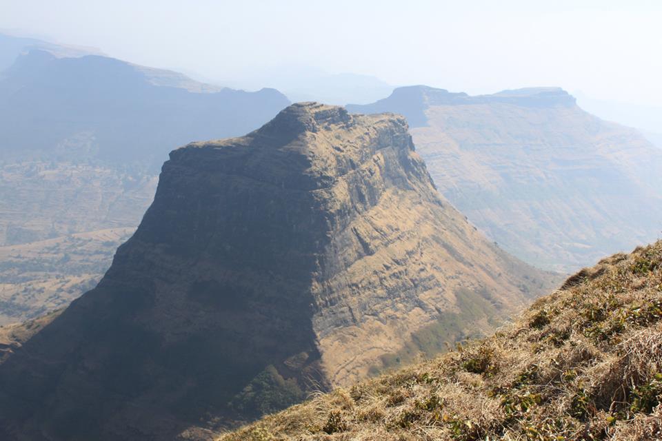
On the way we could see the mighty Rantangad.
Ratangad at a distance
Samrad was once a very sleepy not so disturbed village. Four years ago when I had made the trip for the first time, the villagers had a look at us as aliens from the towns, but now the place was buzzing with people. We parked our car and headed straight to the Sadhan Valley entrance.
Selfie before we begin the Sandhan Trek
The route leading into Sandhan Valley is marked and you can easily find this.
Ratangad from Sandhan Trail
As you walk ahead you come across a small jungle trail at the end of which is the Sandhan Valley.
At the Jungle Trail leading to Sandhan Valley
Steadily we came near the opening of the valley which is small at first but then shares its surprise.
Stream of natural water, the real mineral water
You come across a sudden drop to the narrow stream of water and witness the huge bolder lined-up one after the other.
Bolder as the way !!!
The first part of Sandhan is easy as you make your way through a lot of bolders. They are unending. You need to have good shoes that can survive. Also one thing that we should be aware off is not to jump at such locations, because if you injure yourself, there is no easy way out and medical help is not near.
Bolders and their size. The way is between them
The Water Passes
After the first drop, there are three water passes that you have to go through. The first two are easy and the water level thankfully is manageable, but the third water pass is deep and the water is chest high.
Sneha making her way through the first water pass - Water is deep in places but passable
At the second water pass you need to take off your shoes, the water is knee deep. If you are fine with wet shoes, then just walk into the water. Always remember that wet shoes take time to grip on rocks and they are slippery, so thread carefully if your shoes get wet.
Sneha at the second water pass
As you move ahead, the valley slowly opens up and narrows down, you keep dropping deeper from the place you started. The bolders get bigger and bigger.
The drop and the now narrower and tighter route
You need to remember one thing when you are in Sandhan Valley, there is no place to take a bio break, so if you need to go, go in the before you begin the trek.
Me and Sneha at one of the many drop
The narrower pass and also the place for the third water pass
At the third water pass

The third water pass is about fifty meters long with water reaching chest high.

Some other groups making their way
One has to carry all his belonging in a backpack and carry it over ones head. Remember that you are going to get wet two times. Your clothes dry off by the time you make it to the end of the Valley.
Me making my way across the third water pass
The long walk into the Valley of Shadows
After crossing the water pass, you come across a long walk-way. At this point you are in the absolute middle of two mountains which are now running parallel to each other.
The walkway and the two mountains running parallely
The view of Valley of Shadows
The walk is peaceful and the sunlight plays the game of hide and seek which is mesmerizing to witness. At one point of the walk, the valley is at its narrowest. The sun rays coming through it are a view to be seen. This walk-way and route is a paradise for photographers.
The game of shadows
The narrowest place in Sandhan Valley
View when you are going through the narrowest section
There are unending bolders all the way.

The view of the Bolders
We take very few selfies, but this was one location where we took a selfie :)
Selfie with Wife
After a walk of about 30 mins, the valley opens up completely and there is drop of more than thousand feet at the end. One can walk down this valley. There are three rappelling points further which need expertise. 
The open view of Sadhan Valley
When you look beyond this point, you get to see bolders of the size of a small goods carrier vehicle :) We decided to take rest at this point and munched on our snacks. We had carried dry fruits, groundnut chikki (bar) and some fresh fruits.
Selfie time
The view of the Valley one last time before we return
During the monsoons, this place is unreachable. There are large water rapids  and eventually form long waterfalls. After spending three hours within the valley we returned to the base village.


The water pass video


The end of our trek
After returning to the base village, we had a simple yet delicious lunch, freshened up and moved on to Nashik.
Our Delicious Lunch - Homemade
We traveled via the Igatpuri-Goti road towards Nashik. We had plans to visit Sita Guha (Sita Caves), Pandav Leni (Pandav Caves) the next day and enjoy some local Nashik cuisine and return with souvenirs and we did that.
The Nashik Misal a local fast food cuisine
It was a very satisfying trek of sorts. I wont be returning soon to this place now. The memories and the moments will remain with me forever. Travel whenever you have time and invest in journeys which will remain with you. Yes click pictures, but i would recommend you enjoy the moment of being there, because in the noise of our social media lives we have forgotten that :)

Hope you enjoyed the trek and the images. Please leave your comments and feedback. Ciao

Some points to remember:

1) Do not litter Sandhan Valley with your snacks packets and water bottles. Nature has not asked for them. Please take them back and dispose correctly.

2) Wear easy going clothes that can take the stress and strain of stretching.

3) Please carry enough water to drink and some fresh snacks as you do have anything available in between the valley walk.

4) Rappelling is a available in the base village, if one is interested.

5) Carry good water-proof backpacks, first-aid kit and extra waterproof gears, extra clothes, good sun caps and goggles etc.

6) Take selfies and photos carefully. Watch-out for minor rocks falling from the top of the valley, hence walk in the center.

7) Do not drink and avoid smoking at such locations.

8) Carry some old clothes, utensils and things that you do not use, the villagers may make some good use of it.

Contact in Sandhan
Name: Namdeo Bhande
Contact: +919689579281 (Preferable way to contact is phone call or SMS as there is communication range issue. Also let him know you got the contact from me)
Can help with: Accommodation for groups, couples etc, Rappelling activities, trek guide.

Tuesday, 25 December 2018

Range Trek of Fantastic Four

Mulher-Mora-Salher-Salota
It was in the chilly month of February 2018 when we planned our Trek to Fantastic Four. Fantastic Four are made up of four high grade forts namely Mulher, Mora, Salher and Salota. It is the site of the highest fort in the Sahyadri mountains and the second highest peak at 1,567 metres or 5140ft after Kalsubai in Maharashtra. It stands ranked as the 32nd highest peak in Western Ghats. Fantastic Four are located in the Satana Tehsil of the far stretched district of Nashik. The forts are on the border between Maharashtra and Gujarat.

We planned a trek to these forts on 10th and 11th of February 2018. We a team of thirteen traveled in a Minibus starting from Pune on 9th February 2018 late night starting at 10 pm. We had four coordinators for this trek. Yogeshwar Chaudhari, Dilip Ochani, Ganjanan Patil and me. We all worked in the same organization at one point of time but as life goes on, we had moved in our professional careers as well. We had a busy day on 10th February as we had to ascend and descend two forts Mulher and Mora and ascend the third Salher for night stay. This was going to be a action packed journey filled with adventure, thrill and the satisfaction of being away on ME time with friends.

The Night Drive
I have apprehensions of driving at night on the Pune-Nashik highway. At that time this highway was undergoing six-lane work and had lots of diversions. In certain sections the road is just a two-way road which makes overtaking precarious, add to this the continuous conversation with the driver to keep him on his toes :) and staying awake till you reach the base of Mulher as decided and planned. While we were travelling through Bhosari a village on the way, we witnessed an accident where the ones involved were killed. This was a rude reminder that night rides are difficult and scary. This incident added to my apprehensions. Yogeshwar and me were the only ones who had traveled to these forts prior. We decided to stay awake till we reach the base of the Mulher fort. We took our first break at Narayangoan a village on the Nashik Highway, famous for its Masala Milk (Flavored Milk), by the time we reached Narayangoan it was already midnight, we had five more hours to travel. The driver was a young lad and was aware that he had to drive through the night. While at the Narayangaon, he spoke to me at lengths about the journey and asked to warp up the break quickly as we had to cover a lot of distance. We spent about 15-20 mins and then zoomed our way towards our destination, Mulher fort base. We reached Nashik around 3am in the morning, we had to go more 120 kms from there. The night journey was difficult for Yogeshwar and me as we had to stay awake all night and also manage stops for the driver.

The Morning at the base of Fort Mulher

We reached the base of Mulher fort at 6am in the morning, we immediately asked the driver to take rest as his services were not needed until the mid of that day. He was so tired that he slept right-away. We asked our team to quickly prepare their backpacks with the most minimal of things that will be needed during the ascend. We were going to return to the bus in the afternoon. We freshened up and were ready for the climb at 7.30am. For breakfast we had to prepare a simple sandwich of Jam, Cheese slice and bread. There were no luxuries of any other beverages.
Mangi-Tungi in the background - The first pic of the day
As we started climbing, we witnessed the site of fort Hargad in the background. When trekkers plan a range trek, they include fort Hargad in this but we skipped it. 
Fort Hargad
The way to the top of the Mulher fort is now accessible and easy to climb.
The Walkway to fort Mulher
If you plan to spend time on the fort you can use the easy path but if you have three forts to climb and descend in one day, well you should always take the short route.
Nhavigad - Mangi- Tungi on the climb to Mulher
As you climb and gain height you come across a scenic view of Nhavigad and Mangi-Tungi at a distance on the Selabaari Mountain Range . Nashik offers some of the best scenic views,this was one of them.
View during climb
As planned, we had our breakfast near the water tank on the way near the Ganesh Mandir. The water tank has a Ganesh temple nearby which is a good place to halt and take rest. It is better to rest for a while than climb the fort at one go. Conserving energy was the theme of the day :D
Base Entrance Door of Muler
Base Entrance Door of Fort Mulher
The water tank and Ganesh Temple is a scenic place. Looking at the size of the water tank, in the past this must have been a busy place.
Water tank on the way to Mulher and Hargad in the background
There is a proper walk-way that has been now built to lead you up-to the base of Mulher, but that walk-way is time consuming, hence we took a short route from this water tank. The incline is high, but if you can cover this distance, you can climb the fort a little quicker. The entrance to Mulher is hidden and it does not have a direct access and reveal itself easily. The entrance is visible only after you climb a certain point. The entrance is between the ridge of Mulher and Moragad.

Moragad from the ridge of Mulher
The Entrance to Mulher and the top
From a distance while climbing Mulher, you will see a carving of the Lord Hanuman which is colored. That is the marker, which tells that the entrance of Mulher is nearby is to the left of that carving. As you approach the Lord Hanuman carving, the entrance to Mulher is revealed.
The entrance of Fort Mulher now visible
It took us nearly two-hours to reach the entrance of Mulher.
Entrance to Mulher
The entrance is a series of stair climbs and series of doors.
Steps that lead to the first door of Mulher

First entrance door of Mulher

And then you still go through another door :) This is so strategic in design when it comes to defending the fort. You fight tooth and nail till the last man and also funnel the enemy entrance to two-three even if they are in numbers. There are few caves near this door which have a capacity of twenty to thirty people. This place also has a water hold nearby which can be used for drinking purpose if you plan to stay at Mulher.
Second Entrance Door


Final Entrance Door to Mulher
As you climb through all the door and make it to the top of the fort, you are first hit by the thud of the high and strong winds that flow over the fort. Then when you look around you see the scenic beauty of Satmala Mountain Range. The view cant be described in words, but it is beautiful. I was waiting for this moment for the last three years.
Satmala Mountain Range from Mulher Top
The view from the top of Mulher is mesmerizing, you can literally count mountains after mountains. For any trekker this view showcases some of the famous forts in the region. One can easily recognize forts like Markandya, Kanchana-Manchana, Ravlya-Javlya and fort Dhodap at a distance. These forts are doable and are often done as Range treks. One week is enough to do all these treks if you have the endurance and the strong will to do them walking, climbing all this while.
Fort Dhodap from Mulher top
Atop Mulher there is a water tank which is huge and has water all year round. 
Water tank atop Mulher
Mulher has very few fort structures which are in good shape. Most of the forts structures have fallen and the fort is barren atop.After enjoying the scenic view of the Satmala Range, we decided to descend towards Moragad. Mulher and Mora are twin forts connected to each other. While moving towards the exit of Mulher you come across the remains of the central courtyard doors.
The last remains of the courtyard doors, only structure standing atop the fort
Well the era that these doors have seen and witnessed would be something that we will never know,but they have stood the toll of time.
As pointed out, the only structure that is till standing
The Descend and climb of Mora
As you move towards the Mulher descend, you come across some fallen bastions of the fort which lead towards Mora. The path is narrow and tricky and needs utmost attention as it has exposure on one end and a tricky rock patch with a small opening due to rock fall that has happened over the years.
The narrow pass from Mulher to Mora
After coming through the narrow pass you come towards the bastion between, Mulher and Moragad.
The small opening that you come out off from Mulher
Steps that Descend from Mulher and lead into Moragad
Once you descend from Mulher, you come across a narrow pass that connects Mulher and Mora. Here you get to witness some of the last remaining Bastion of the fort which are still strong.

Fort Mora
We did not spend a lot of time on Moragad as this fort too is barren. The only good thing here is the traverse stair climb from Mulher and the descend. There are various carvings for Lord Ganesh and Lord Hanuman near the entrance wall of Moragad fort.
Lord Ganesha Carving on the walls of Moragad
Lord Hanuman Sculpted on the walls of Moragad 
It was 11.30am and we had completed exploring both Mulher and Mora. We started our ascend as planned towards Mulher base as we had to also travel for Salher-Salota after our lunch. It took us nearly two hours to descend through the rocky patches of the fort Mora descend. There is a Shiva temple while you descend. Then Shivling is hidden below the temple and you have to walk through a small opening to reach to it below. After spending time at the temple and a long chat with a lonely Saddhu, we reached our bus at around 2pm. We freshened up and headed to village Mulher where we had arranged our lunch. For lunch, the village contact in Mulher had arranged a simple lunch of Roti, Rice and Cabbage veggies. We also had tea and coffee before we left for the base of Salher which is Salherwadi.

The Mighty Salher and Salota

Salher is the highest fort in Maharashtra and it has the mighty and tricky Salota by its side. Considered as one of the most endurance driven trek, this fort tests your patience, strength and will to climb all at once and that too if you are carrying a heavy backpack with you.
The team of trekkers - Salher and Salota in the background
We reached Salherwadi, the base village of Salher and Salota forts at around 3pm on 10th February. There are two base villages for Salher and Salota. One can either climb from Waghambe or through Salherwadi. We climbed from Salherwadi. We planned to stay in caves of Salher for the night. We all had our backpacks ready for a night stay. It was close to ten kgs with all the items that were needed. We divided all the necessary equipment like utensils for night cook, groceries like rice, onions, potatoes, spices etc. We were sure that we will get firewood in and around the caves but carried about two kgs of firewood chips in our backpacks as safety. We started climbing towards Salher at 3.30pm. We had a target to reach the Salher top by 7pm.
Wheat Grain Field on the way to Salher
The climb to Salher is excruciating and really tests your endurance. The climbs are un-ending and you have to take breaks at regular intervals, add to this the pressure of climbing within time and the ten kilogram backpack.
Gajanan Patil during the climb
One of the many stops during the Salher climb
You have to climb three different levels from Salherwadi each with its own level of difficulty. You come across a steep traverse which leads you to a narrow ridge which connects both Salher and Salota. For Salher you have walk straight for about three hundred meters and then you have to climb upwards towards Salher. If you go left, then you climb towards Salota. We took a break at the ridge as the next stage of climbing was going to be on the steep steps of Salher. The steps are literally at an angle of seventy degrees unending and zapping energy at every step. During the step climbs, you get a good glimpse of Salota.


Salota from the steps of Salher

Steps Leading to Salher
Climbing with backpacks at an steep angle
When you look around while you are at the stairs you come to know of the actual height of the fort to which you have climbed.


The view of Salota from Salher Ladder
We reached the top of Salher at around 6.45pm. The view of the sunset was amazing but we missed this as the sun-down happened at the other end of the fort. We had to get ready now to settle down in the caves and prepare our dinner. What a day we had, climbed three forts and yet there was work to be done.
Steps at the entrance of Salher

The Entrance of Salher
The entrance to Salher is an ancient fort architectural genius of defending to the last man. All approaches to the fort have very large steps that can tire any approaching enemy.

The Night on Salher

We nicely put-up in the caves at Salher. The caves are full of clever rats and we were aware of this fact and advised our fellow trekkers to hide food in the backpacks. When you are on night treks, there is lot of work to be done. This instills the belief of bonding and working like a team. We split up in three teams. One team was put in-charge of water, second team was put in-charge of cooking and the third team was put in-charge of collecting dry grass for burning purpose. Dilip and me were on the grass task team, Yogeshwar on the water team and Gajanan was going to handle the cooking team. Yogeshwar and me switched task as fetching water too was a task in itself. You have to travel around five hundred meters. Add to this the cold in which you have to get your hands wet. The water in the water tanks was not good as villagers had put wheat dough in it for the fishes. We had our task cut out with getting clean drinkable water. For dinner we prepared dal-khichadi to be enjoyed with ground-nut chutney some pickle and papad. The night was windy and cold. We all were fast asleep as the tiredness of the three trek climbs had got to most of us. 

The Morning at Salher
It was 11th Feb and we had Salota to climb and descend, but before that we had to explore Salher and visit the Lord Parshuram temple atop the fort. The view in the morning was as scenic and as beautiful as the landscape. We were the only trekkers on the fort so you can say the fort was ours for the taking.
The view from the caves of Salher

Large Water Tank just Opposite Salher Caves
Our kitchen and stay for the night

Our kitchen that served us well

The cave we stayed in
Temple beside the cave

Partially covered cave protects from the night wind
The morning was pleasant and had a cool breeze to enjoy. Everybody freshened up and we prepared coffee and had some left over rice of last night along with snacks we had in our backpacks. We had Maggi planned for the breakfast but all were of the opinion that we should have it later in the day at the base. The Lord Parshuram temple is at the highest point on the fort. You have to climb for 20 to 30 mins to reach that point. This to me is one of the most scenic locations of Sahyadris. The climb is precarious and one needs to be careful while you walk as there is steep inclines in places with minimal safety.
The steep incline. You slip you fall

Glimpse of Salota when you are climbing to Lord Pashuram Temple
While climbing to the Lord Parshuram temple, you get a great glimpse of Salota on the way. This gives you a perspective of how high you have climbed :)
The view from Parshuram temple of the entire mountain plateau is beautiful and breath taking.
Lord Parshuram Temple of Salher
Team members enjoying the view that Salher offers
We spent time there doing Pranayam and Yoga and enjoying the wind and the silence that we so miss in our busy lives in the city :)
Ancient Havan Kund at Salher
Lord Parshuram temple from a distance
It was time to wrap-up on Salher and head to Salota. We had to reach our base village Salherwadi by the 3pm. We had a long distance to go back to Pune. As planned we descended towards the ridge of Salher and Salota.
Me after wrapping up our Salher Trek
I had decided to click some pics while descending, so saved some images for the last.
The walkway along the perimeter of Salher fort

View of Salota walkway from Salher
 Pics of difficult steps on the way
I have put up some videos of the Salher-Salota trek on my Instagram handle abhijit_more, you can visit and see for yourself images of this and some other treks as well. We descended Salher quickly in about one hour and then alighted our backpacks at the ridge where Salher and Salota routes meet.

The Salota Climb
The Salota climb is tricky and a bit risky. The path towards Salota is very narrow and there can be only one person walking at a time. You have the fort to your left and a inclined valley on the right. To climb Salota you need to walk about three hundred meters and then climb upwards. The path to Salota is not marked as trekkers do not often visit this fort. You need to have good shoes and sense of foot grip as there is certain amount of scree. This is due to the fact that the fort and walkway is not visited often. You can get some help from goat herders who often come. On a physical note, you need to stretch a lot at certain points on the way. You need to wear good clothing that can take the strain of stretches. While climbing you also get to experience a small rock patch which  can be climbed easily as there are good holds. Doing it one at a time is the best way to climb safely.
Narrow Walkway towards Salota with Salher in the background

Steps leading to Salota
The steps are really large in height and you need to climb with all your fours. There are various rest places on the stairs to Salota as the climb is literally at seventy degrees at one point of time. We climbed for almost 50 mins and  reached the entrance of Salota. The entrance is barely open now as the door has collapsed. You have to make way through various small openings.
Making our way through the fallen rocks at the entrance of Salota
The rocks at the entrance
After you go through the entrance you have to climb few more steps before you come to a walkway similar to Salher.
Walkway leading to the top of Salota
View of Salher from Salota Walkway
As you move ahead on the walkway for Salota top, you come across large water tanks to the right. We witnessed that the tanks were filled to the brim that too in the month of February. The water was clean and naturally cooled.
Water Tanks on the way to Salota
Drinkable Water

Steps of Salher from Salota
From the walkway of Salota you get to see the enormity of Salher. Every aspect of the fort can be defined.
One of the door of Salota

After clicking few pics we climbed to the top of Salota. The view of Salher from Salota is very scenic and mesmerizing. We also got to witness a landslide that happened on the way to Salher recently. 
Salher from Salota Top
After spending time and taking pictures, we descended by 2pm towards the ridge where Salher and Salota connect. We took a half hour break and ate snacks that we were left with. We reached the base village by 3.30pm. We had one more food item remaining and that was Maggi Noodles, the trekkers favorite. We caught hold of a villager and asked him to prepare Maggi. Salherwadi is a extremely rural area and the villager was astonished to see Maggi in his hands and did not have the knowledge to prepare. One of our team member assisted him in preparing the food item. What was satisfying was the sight of a couple of kids who belonged to the villager seeing the noodles for the first time. We shared our food with them and the kids were overjoyed. It was done. We had safely completed the trek with the minimal of dings and bangs :D

With lots of memories and pictures, we started our return journey to Pune around 4.30pm and reached Pune by 11pm in the night. It was an awesome journey which i enjoyed to the fullest. Hope i have done justice to the trek by making an effort in writing it down in December 2018, a good nine months late. 

So until the next trek which i will surely put in words more quickly, see around trekkers and readers. Please let me know your comments and feedback.

Hope you enjoyed the trek :)
Some basic information about the forts:

Mulher-Mora
How High: 4,200 ft (Mulher); 4,400 ft (Mora)
Preferred Base Village: Mulher Village
Travel Route: Nashik highway from Pune (NH60) – Do not take the Saptashrungi route
Travel time: 7-8 hrs (from Pune) – 320kms
Total trek time: 6 hrs max
Difficulty: Moderate
Endurance: Medium to High

Salher-Salota
How High: 5140 ft (Salher); 4248 ft (Salota)
Preferred Base Village: Salherwadi / Waghambe
Travel Route: Mulher to Salherwadi
Travel time: 30-45 mins (from Mulher) – 35kms
Total trek time: 10 hrs for Salher and Salota including a night stay
Difficulty: Moderate to Difficult
Endurance:High

Some tips for this trek:
1) Plan the travel route accordingly as Salher and Salota need more time than you think
2) You can also do Salher Salota  on day 1 and day 2 Mulher Mora.
3) Do all activities safely as there is no medical facility available within 1 hours distance.
4) Water is available on all forts, but Salher didnt have good quality drinking water this time round.
5) Try and make contact with villagers as they can help with basis, before and after the trek.
6) Carry first aid and emergency medical kits.
7) Please do not litter our forts and please do not drink. Villagers will take strict action if they come to know of any such activity.
8) Keep the sanity of the temples and caves, they are sacred to the villagers.

Travelogue - Nashik Diaries - Day 2

Travelogue - Nashik Diaries - Day 2 The plan for today was that of sight seeing. We had planned to visit Pandav Leni Caves, Someshwar temple...